Longnan Project
The Company made good progress in the exploration program on the Yejiaba Project during 2013. The sample work performed on this project, in particular on the Baimashi North and East Targets, consisted of 912 rock chip samples, 818 soil samples, 41 stream sediment samples and 339 trench channels. The result based on these samples, reviewed by an independent consultant, indicates the Baimashi North Target is the only target that hosts sufficient size and grade potential to produce a substantial gold deposit.
Exploration Activities - Longnan Region Projects
The Company's wholly-owned subsidiary, Minco China, held ten exploration permits in the Longnan region in the south of Gansu Province in China during 2013. The Longnan region is within the southwest Qinling gold field. The Longnan region consists of three projects according to their geographic distribution, type and potential of mineralization.
| Yejiaba: | | Includes four exploration permits along a regional structural belt parallel to the Yangshan gold belt. The potential in this area is for polymetallic mineralization (gold-silver-iron-lead-zinc). The Company completed the NI 43-101 compliant technical report (refer to above) on Yejiaba Project, which is available on SEDAR.
|
| Yangshan: | | Includes five exploration permits located in the northeast extension of the Yangshan gold belt and its adjacent area.
|
| Xicheng East: | | Includes one exploration permit for the east extension of the Xicheng Pb-Zn mineralization belt. The potential in this area is for polymetallic mineralization (gold-silver-lead-zinc).
|
Yejiaba Project
The Yejiaba Project is located along the collisional boundary separating the Huabei and Yangtze Precambrian cratons. This major E-W trending collision zone has localized a number of large gold and polymetallic deposits within a geologic province that is often referred to as the Qinling Orogenic Belt. Gold and polymetallic mineralization on the Company's lease package is generally hosted in Silurian-Devonian, thin-bedded limestone interbedded with phyllite. Mineralization is associated with shears and quartz veins, with higher grades typically found along sheared contacts separating massive limestone from the thin-bedded limestone and phyllite unit. Granite porphyry and quartz diorite dykes tend to be spatially associated with mineralization. Alteration accompanying mineralization consists of weak silicification and pyritization with carbonate veining and secondary carbon. Small quartz veinlets are noted in several places. Associated metals consist of silver, lead, antimony and arsenic.
Semi-regional geochemical anomalies were first delineated by the Company in 2005, extending 10 km along a hydrothermally altered zone that follows a NE trending thrust and regional unconformity.
Subsequent work between 2006 and 2012 has included traverse-line investigations, soil sampling, geologic mapping, geophysical surveys (ground magnetic and IP), trenching and drilling.
To date several targets have been identified and tested including: Shanjinba (Zone 1 and 2), Yaoshang, Fujiawan, Baimashi, Bailuyao, Baojia and Paziba.
The Company engaged an independent consultant to conduct a detailed review of the Yejiaba Project in April 2013, in particular to focus on the Baimashi North and East Targets. The sample work performed on the Yejiaba project during 2013 consisted of 912 rock chip samples, 818 soil samples, 41 stream sediment samples and 339 trench channels. The detailed results at the Baimashi North and East Targets are described in below.
During 2012, the Company completed an extensive surface trenching program at the Shajinba target on the Yejiaba project including 72 trenches for an aggregate length of 2,396.3 m and three diamond drill holes for an aggregate total of 1,260.2 m. The rock chip sample results at Shajinba indicated there was no significant mineralization within the target area. A comprehensive discussion and data compilation of previous exploration work up to the end of 2012 for the Shanjinba target were included in the Company's Annual MD&A for the year ended December 31, 2012, dated April 1, 2013, available on SEDAR at
www.sedar.com.
Sampling and assaying
The channel samples taken in the trenches are generally 10 cm wide; 5 cm deep, lengths are typically 1m but can be slightly longer or shorter to match geological boundaries. Only significant channel sample results are reported below, where composited gold grades are over 0.50 g/t. Reported composites may comprise individual samples with gold assays lower than 0.5g/t if it is deemed that the geology and mineralization is continuous over the interval. Channel sample intervals may not necessarily represent true thickness of the mineralization.
Sample preparation was performed by independent laboratory SGS-Tianjin, at their laboratory in Xian (PRC). Pulps are then analyzed at the SGS-Tianjin assay facility in Tianjin. Sample QAQC methods consisted of insertion of blank and duplicates in the field (one in twenty samples), while SGS-Tianjin inserted analytical duplicates and reference standards into the sample stream at their laboratory.
Baimashi Target
The Baimashi gold-antimony mineralization was discovered on the boundary between Weiziping-Baimashi and Shajinba-Yangjiagou permits and includes the Baimashi North Target that was identified in 2013, located approximately 1Km north of the Baimashi Target; and the Baimashi East Target.
During 2013, the samples in Table 1 were collected within the Baimashi North and East Target. Out of total samples, 118 trench, 75 soil and 37 rock samples were collected from Baimashi East, but the results of these samples demonstrated the gold values in the Baimashi East are tightly confined to narrow structure and thereby effectively diminished the target's size and significance. The Company has no further exploration planned on this target.
All of the exploration to date conducted during 2013 indicates the Baimashi North Target is the only target that hosts sufficient size and grade potential to produce a substantial gold deposit. The Company decided to drill-test this target in early 2014 with a scout drilling program to determine whether or not sufficient lateral and vertical continuity of gold mineralization exists to support a large scale, low-grade open pit operation.
| Table 1.Ā Summary of sample types collected within the Baimashi Targets |
| |
# of Samples |
Gold Range (ppm) |
Average Au (ppm) |
| Rock Chip |
912 |
<0.005 - 47.115 |
0.729 |
| Soil |
818 |
<0.005 - 3.968 |
0.055 |
| Trench Channels |
339 |
<0.005 - 14.250 |
0.190 |
| Stream Sediment |
41 |
<0.005 - 0.226 |
0.015 |
Baimashi North Target
Gold Mineralization Observed within the Baimashi North Target
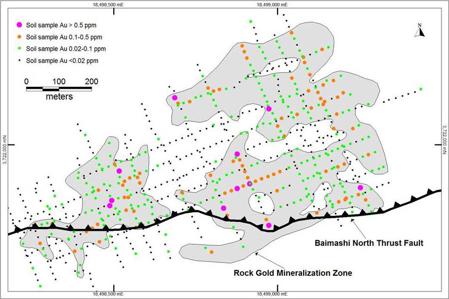
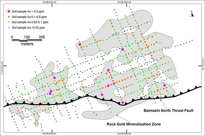
The Rock Gold Zone shown in Figure 1 represents the distribution of rock chip gold values exceeding 0.100ppm, and the zone boundaries were defined by combining the rock chip and soil sample results together with the structural data. The gold-in-soil distribution fairly represents the gold zone.
Figure1. Outline of Baimashi North Gold Mineralization Zone relative to soil samples results
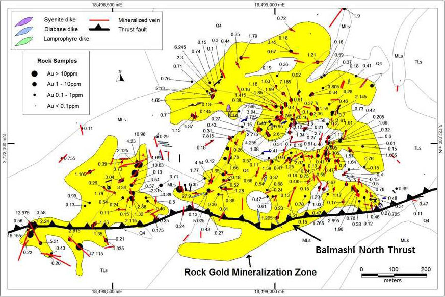
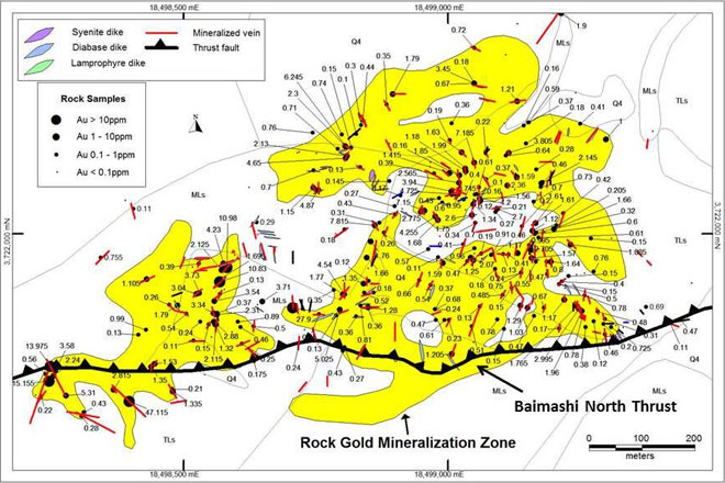
In Figure 2, the same Rock Gold Zone is shown relative to the distribution of rock chip sample results together with the mapped mineralized structures (shears, veins, dikes). Here again, the sample data fits well within the zone boundaries, which suggests that the soil sample values generally do a fair job of reflecting the rock sample data. The dominantly northeast-trending Rock Gold Mineralization Zone is approximately 1,200m long by 600m wide. It measures 317,000m2 in plain view and is open to the north. The Baimashi North Target certainly possesses sufficient size for hosting a large gold deposit but will need sufficient gold grade as well
Figure 2. Outline of Baimashi North Gold Mineralization Zone relative to rock chip results and mineralized structures.
 Samples collected within the Baimashi North Target
Following the encouraging results found in the third quarter of 2013 described below, a total of 589 soil samples and 39 rock samples were collected within this target during the fourth quarter of 2013. The soil sample results show a gold range from 0.005 to 3.968 ppm (refer to Table 1).
During the year ended December 31, 2013, 247 rock chip samples, 125 soil samples and 41 stream sediment samples within Baimashi North Target were collected.
The 247 rock samples collected within the Rock Gold Mineralization Zone run from 0.005 to 47.115ppm Au and average 1.49ppm, which is a potentially economic grade for an open-pit operation if this grade can be maintained. A rough analysis of the rock sample data is presented in Table 2, where we see a high percentage of samples (39%) carrying gold values exceeding 0.5 g/t, while 68% run in excess of 0.1 g/t. Six samples included in the >3.0 ppm Au category in Table 2 exceed 10ppm Au. If these six high-grade samples are taken out, the overall average grade drops to 1.00ppm, which illustrates the weight carried by high-grade numbers in this zone.
| Table 2.Ā Summary of rock chip sample results (excludes dumps). |
| Sample Ranges |
Number of Samples |
% of Total Samples |
Average Au (ppm) |
Average As (ppm) |
Average Sb (ppm) |
| >3.0 ppm Au |
22 |
8 |
8.391 |
4292 |
99 |
| 1.0-3.0 ppm Au |
48 |
17 |
1.764 |
2358 |
66 |
| 0.5-1.0 ppm Au |
41 |
14 |
0.691 |
1797 |
54 |
| 0.1-0.5 ppm Au |
83 |
29 |
0.276 |
1340 |
25 |
| <0.1 ppm Au |
94 |
32 |
0.027 |
241 |
8 |
The overall gold grade distribution is summarized in Table 3. This is obviously a low grade system, and the amount of high grade found within the low-grade blanket will determine whether or not this target can be economical.
| Table 3.Ā Distribution of gold grades in 247 rock samples collected at Baimashi North Target |
| Grade Range (ppm Au) |
<0.1 |
0.1 – 0.5 |
0.5 – 2 |
2 – 4 |
4 – 6 |
6 – 8 |
>8 |
| % of Total |
18 |
32 |
33 |
9.3 |
3.2 |
1.6 |
2.4 |
The rock samples collected within this zone tested a variety of geologic features and they can be grouped into vein/fault, dike-related, and altered rock types. The carbonate veins and altered faults usually range from 0.1m to1.0m wide, and the sampling often includes some of the surrounding low-grade wallrock. Altered dikes and dike margins were also sampled as a separate rock type, as were several zones of altered phyllitic limestone (the "altered rock type") hosting stockwork-type carbonate veinlets.
Averaged Au-As sample results for these three rock groups are compared in Table 4. Based on the As:Au ratios, arsenic values look to be following the intrusive dikes and sills, which suggests a congenetic relationship between the intrusive plumbing and Au-As mineralization. In contrast, the lower As:Au ratio seen in the vein/fault type is attributed to post-intrusion mineralization in younger, more dilatant zones.
| Table 4.Ā Comparison of Au-As mineralization in major sample types at Baimashi North Target |
| Sample Type |
ĀAve. Au (ppm) |
Ave. As (ppm) |
As/Au Ratio |
| V:Ā Vein/Fault type |
2.190 |
2185 |
997 |
| D:Ā Dike related |
0.951 |
1726 |
1815 |
| R:Ā Altered rock type |
0.958 |
1325 |
1383 |
Yangshan and Xicheng East
During 2013, the Company did not conduct any exploration activities on these two projects except for maintaining the exploration permits in respect of the projects.